Tyburn (London, England)
Enlarge text Shrink text-
 Place
Place

-
Save successfulThe item can be found in your Personal ZoneשגיאהLog in to your account to save

- Brooke, Alan. Tyburn, 2004:front jkt. flap ("Tyburn, close to present-day Marble Arch, is synonymous with public hanging")
- OCLC 53242937(hdg.: Tyburn (London, England))

RioVerde
, PD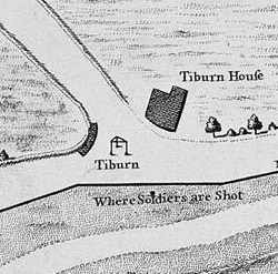
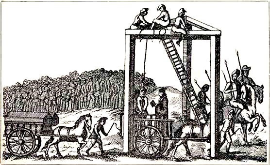
Tyburn was a manor (estate) in London, Middlesex, England, one of two which were served by the parish of Marylebone. Tyburn took its name from the Tyburn Brook, a tributary of the River Westbourne. The name Tyburn, from Teo Bourne, means 'boundary stream'. The parish, and probably therefore also the manor, was bounded by Roman roads to the west (modern Edgware Road) and south (modern Oxford Street). The junction of these was the site of the famous Tyburn Gallows (known colloquially as the "Tyburn Tree"), now occupied by Marble Arch. For many centuries the name Tyburn was synonymous with capital punishment: it was the principal place for execution for London and Middlesex criminals and convicted traitors, including many religious martyrs. In the 18th century it was also known as "God's Tribunal". Hangings at Tyburn often included a sometimes raucous procession of the condemned from Newgate Gaol in the City – at the end of the 18th century, the hangings were moved to Newgate.
Read more on Wikipedia >